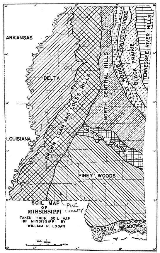
 Soil Map of Mississippi 05-1 (Click to enlarge) |
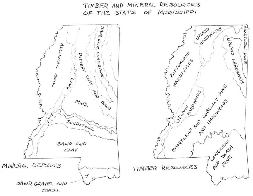 Timber Resouces of Mississippi 05-2 (Click to enlarge) |
|
|
|
Summary: The Natchez District became a part of the United States after the
Revolutionary War. The surrounding area had to be wrested from the Spanish in
a struggle that lasted until 1812. Between 1810 and 1816 the white population
increased by a factor of ten as settlers came in from South Carolina and elsewhere.
The Scotch-Irish, who were without money, settled to the east of the Natchez
District in the Piney Woods.
The locale to which our ancestors were drawn was a strategic hot spot of its time. Pike County itself is near neither rivers, mountains nor seas. There is nothing to distinguish it from thousands of other places located elsewhere in the rolling red clay hills of the Southland except that some miles to the west is the Grandfather of Waters, the Mississippi River, and to the south, the already old Latin City of New Orleans . The Natchez District was the extreme western and southern limits of the territory claimed by the United States in 1798. That is why it was of such great strategic value to the US and why it was acquired from the Choctaw in 1801.
The area had been known to the Europeans for over 100 years. The French explorer Pierre D'Iberville had passed through the area in 1699. It was he who named the Amite River after the native peoples who, he said, were friendly. Hence Amite from the French for friend. The river flowing through Pike County he named after the Tangipahoa Indians who lived in the southern part of the county along what was later the Louisiana state line. Tangipahoa means corn-cob. The Tangipahoa people were farmers and, in many ways, were similar to the Choctaw. A few of the Choctaw had farms in the northern part of Pike County but the major towns of the Choctaw Nation were far away in central Mississippi.
Over the years several settlements of Europeans were attempted in the area of Natchez. This is about 80 miles to the northwest of Pike County on the banks of the Mississippi River. By 1776 there was a sizable colony of English-speaking planters there. The soil was suitable for tobacco and that was their main crop. Because of the existence of this isolated settlement called the Natchez District, suitable soil and easy access to the Mississippi River, most of the earlier settlers had chosen land to the west of Pike County around Natchez. The farmers of the Natchez District became far wealthier than those who settled in Pike County. Until well into the 1840s they dominated the Territorial, and then the State, economy and government.
By 1798 the United States had gained control of the Natchez District by a treaty with Spain. In April 1798 the United States created the Mississippi Territory with Natchez as its first capital. Shortly afterward an office of the US Surveyor-General was opened in the second capital of the Territory, a new town called Washington barely six miles east of Natchez. A land boom was sweeping the area and settlers were pouring in from South Carolina and Georgia. By 1800 there were 8,850 persons living in Mississippi Territory. The Treaty of 1801 established the border of the Territory just west of the Tangipahoa River but settlers were prevented by law in 1803 from settling that far east. Instead they were encouraged to settle on land closer to the Mississippi River. The land east of the Tangipahoa River and north of Spanish West Florida was still legally part of the Choctaw Indian Nation although no Choctaw actually lived there. In those days the eastern-most white settler lived on the Tickfaw River. In 1804 Joseph Cutrer , from France via South Carolina, settled on a tract east of the Tangipahoa in what is now Louisiana. The land he settled on was actually a part of Spanish West Florida but he may not have known this. He was one of the earliest whites to settle in the area.
Five years after the creation of the Mississippi Territory the US negotiated the Louisiana Purchase with France. France had doubtful title to the land it sold and never fully occupied positions of authority there, even in New Orleans. However the Spanish were in no position to enforce their own claim and the deal between Napoleon and the Americans held. The Louisiana Purchase consisted of land west of the Mississippi including a small area around the city of New Orleans. The cession of the Natchez District in 1798 and the purchase of Louisiana in 1803 did not dislodge the Spanish from what had been until 1779 British West Florida.
British West Florida, known to the Spanish as the West Florida Parishes, consisted of the land south of the present Mississippi state line that was not included in the Louisiana Purchase. The West Florida Parishes were, in other words, that part of present-day Louisiana east of the Mississippi River excluding the area around New Orleans. It seemed to the Americans that it was their "manifest destiny" to get possession of West Florida as well as the Natchez District and Louisiana. Relations between the Spanish authorities and the English-speaking settlers of the Natchez District had never been good. Now the Americans wanted to drive the Spanish from Florida as well.
From about 1805 until 1809 the US Army and American settlers along the border engaged in sporadic warfare with the Spanish troops stationed in Baton Rouge and St. Francesville with the intention of driving them out. The US Army operated from a post called Fort Adams about 25 miles north of St. Francisville. It was the most southwesterly US Army base at the time. It was built to prevent a French or Spanish attack up the Mississippi River. The French or Spanish attack never came and the US Army did not actively attack the Spanish but it did nothing to discourage the settlers from doing so. In 1810 a group of American civilians actually captured the dilapidated Spanish fort at St. Francisville and then, a little later, that at Baton Rouge. The victorious American civilians were settlers led by the Kemper brothers of Pinckneyville. The Kemper brothers later moved to Texas where they continued to cause problems for the Spanish authorities. Pinckneyville, which no longer exists, was a place on the border about five miles southeast of the US Army base at Fort Adams. At the time of its capture by the Americans the Spanish garrison at Baton Rouge consisted of only 28 men. They and the Spanish civil authorities were allowed to leave on foot for Pensacola. The Americans then quickly proclaimed the Free State of Florida and, at the same time, applied for admission to the Federal Union as a State.
US President Madison did not respond to the settler's application for statehood. Instead he sent Mississippi Governor Claiborne to Baton Rouge to establish the Territory of Orleans. This new US Territory included all the land east of the Louisiana Purchase, south of the Mississippi Territory and, according to the Americans, west of Perdido Bay. In practice the new boundary line was the Pearl River because the City of Mobile was not captured by the Americans until the War of 1812.
Before 1810 Natchez was the only town in the region that was not under foreign control. Because of its strategic importance and its rapid growth as a cotton port, the US government built or improved roads leading to Natchez. The US Army widened the Natchez Trace into a wagon road and placed it under the care of the Post Office Department. The US Army also built the Three-Chopped Way from the lower Tombigbee River in Alabama to Natchez in 1807. An older road called "El Camino Real" went from Natchez south to Fort Adams on the Mississippi River and then on to Baton Rouge. A wagon trail led south from Natchez to the growing town of Woodville which had been founded in 1808 and, even without water access, was rapidly becoming the commercial and cultural center of a booming cotton economy. There was another trail that led southeast from Natchez through Liberty in Amite County and then on to Mobile. This was called the Natchez to Mobile Trace and was the only trail that passed through Pike County prior to 1816.
In 1809 the southern portion of the land ceded by the Choctaw in the Treaty of 1803 was organized into counties for the first time. What became Pike County in 1817 was then a part of Amite County. In an area of over 4,000 square miles (which is today divided into eleven counties) the 1810 census counted only 514 white settlers. The majority of these people were located in the area of Liberty, west of present-day Pike County. Growth was so rapid that by 1816 the area around Liberty had a population of 3,365 whites, 1,694 slaves and 19 free Negroes. There was a slave block and, in later years, large homes of planters in and around Liberty. From Liberty oxcarts carried three or four bales of cotton each overland to the port of Natchez, 60 miles to the northwest. In the 1820s the town of Liberty had a shoe factory and a tannery, both operated with slave labor. Somewhat later, in 1828 Gail, Borden made condensed milk there and, still later, Doctor Tichenor invented his famous antiseptic while living in Liberty.
All of this activity was subordinate to cotton. Whitney's gin had made cotton profitable. In 1806 an improved Mexican variety of cotton made it even more profitable. The Mexican variety was crossed with the older black seeded species to make improved varieties that made the State of Mississippi famous. The most famous varieties of all, Belle Creole, Jethro, Parker and Petit Gulf, were bred in Mississippi. The mixture of sandy clay and loess (soil with a high organic component) found in southwestern Mississippi proved to be ideal for cotton culture. Between McComb in Pike County and Liberty in Amite County is the edge of the longleaf pine region. Pike County is on the edge of what is called the Piney Woods. The topsoil in the piney woods is shallower than that in the Natchez District. There are fewer loess covered areas. This meant that the cotton crop was not as profitable in Pike County as it was further west in Amite and Wilkinson counties. There were fewer large plantations and fewer Negroes even though for many years a majority of the population of Pike County was black.
It was to the Piney Woods to the east of Pike County and to Lawrence County to the north that Carolinians from the Piedmont migrated after 1812. These Gaelic-speaking Carolinians were culturally distinct from the German and French-speaking settlers around Orangeburg. They were subsistence farmers and retained elements of their Scotch-Irish culture for many years in the hill country of South Carolina and then in the Piney Woods of Mississippi. So many Scotch-Irish settled in the Pearl River Valley to the east of Pike County that this area was second only to the Natchez District in density of population during the period 1810 to 1830.
In 1948 the author of an extensive work on Amite County (which included Pike County) wrote that "Seventeenth century Virginia was the cradle of Amite County stocks, nearly all of which by 1850 had pioneered 5 to 8 generations on successive American frontiers. Traditions of origin, formal education, trades and professions, and family heirlooms were largely lost. They had been small slave owners and farmers for at least 100 years, mostly Baptists , Quakers , Presbyterians and Methodists. Land exhaustion south of the James River, religious and political persecutions and land speculations urged them into North Carolina, southern and western Virginia before the Revolution and into northwest South Carolina and northeast Georgia after the Revolution." The German-French Varnadoes intermarried with their neighbors, forgot their ethnic heritage, adopted the same lifestyles and soon became indistinguishable from the other Pike County residents.
I have not made much mention so far in this narrative of the original inhabitants of southwestern Mississippi, the Indian people. This is in keeping with the manner in which our ancestors dealt with them. In some ways the Indians were not relevant to this family history. For one thing intermarriage and even friendship was very rare. For another, except for the adoption of native field crops such as corn and vegetables such as squash, European farmers hardly ever adopted the cultural practices of the Indian farmers. Yet the existence of the Indians in the area had serious influences on the white pioneers. As one writer put it, "Fear and a resentment of competition for desirable lands, on a vicious frontier where only the fittest could survive, produced in the white pioneer an almost pathological hatred of the Indian, a hatred that colored all of his relations with the legal residents of any Indian territory." In the next chapter we'll see how the conflicts between the Indians and the whites of Mississippi were finally resolved.
Back to Table of Contents | Chapter 6
Copyright © 1994-2005 by Philip Mullins. Permission is granted to reproduce and transmit contents for not-for-profit purposes.